A few months prior to the trip, we were arguing as to what the name of Korea's highest peak really was. I had a brochure from Rhoda - Mt Halla in Hallasan. Chabs and Yeye told me Mt Halla and Mt Hallasan - it's the same mountain. I don't know what's the confusion with the name, but I was just as adamant on calling it Mt Halla the first few times. And I later found out from a friend (Noel, who will surely comment on this post and) who went to Korea earlier this year that -san is a suffix which means 'mountain' - e.g. Seoraksan, Namsan. Just like -gung for palace, -do for island, -si for city, -dong for district, -gu equivalent to Philippine's barangay, and -ro for neighborhood.
So much for the easy language lesson, let me share our Hallasan adventure.
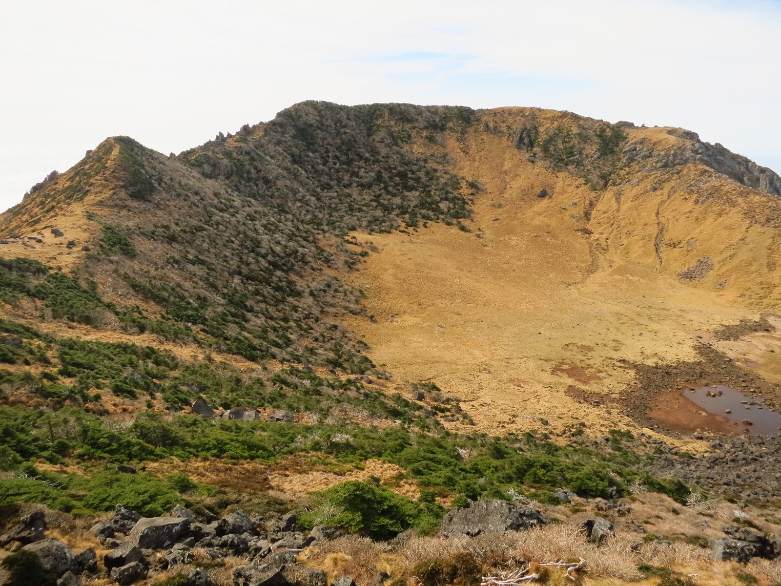 |
| Hallasan's peak |
Hallasan
29 October 2012
0700 to 1830 H
Jeju Island, South Korea
Hallasan National Park is located in the province of Jeju-do, South Korea. It was designated as the 9th national park in 1970. It features the highest mountain in South Korea, the shield volcano Hallasan, also called Mt. Yeongjusan, meaning ‘mountain high enough to pull the galaxy.’ Mt. Hallasan is widely acknowledged by scholars for its research value. It was designated a UNESCO Biosphere Reserve in 2002, and a World Heritage Site in 2007, there are 368 parasitic mountains called ‘Oreums’ (peaks) around Halla Mountain.
Mt. Hallasan is famous for its vertical ecosystem of plants that results from the varying temperatures along the mountainside. Over 1,800 kinds of plants and 4,000 species of animals (3,300 species of insects) have been identified.
Hallasan has six trails: Eorimok Trail(6.8 km), Yeongsil Trail (5.8 km), Seongpanak Trail (9.6km), Seokgulam Trail (1.5 km), Gwaneumsa Trail (8.7 km), Donnaeko Trail (7 km), and Eoseungsaengak Trail (1.3 km). The longest trail is Seongpanak Trail which takes about 4.5 hours.[italicized paragraphs are cited from multiple internet sources]
(Chabs will surely approve of the quoted facts. She almost always tells me my blog lacks information, only treats... To harness the writing skills. Hahaha!)
We were due to climb Hallasan on our third full day in Jeju-do. Originally, we were supposed to bike around Jumnung resort on the first day in the island, rest on the second day, then trek on the third day. But since our itinerary was revised (we were not able to rent a bike at 1600H on our first day), we opted to trek the next day. The night before the trek, Chabs went out to get us KimBap (Kim = nori + Bap = rice) for the trek's lunch food. (KRW 3,000)

We hopped onto a Jeju Intercity Bus (the terminal was a five minute walk from our accommodation) going to Seongpanak. We took Road Bus 5.16 (Jeju, Seongpanak, Seogui) around 0600H, and got off at Seongpanak at a quarter before 0700H.
Bus schedule: 06:00-21:30, 10-15min intervals
Travel time: 30 to 40 minutes
Fare: KRW 1,500

We started at Seongpanak Trail / 성판악 (9.6 km) then traversed to Gwaneumsa Trail / 관음사 (8.7 km). Ideally, it takes 4.5 hours to reach the peak. But it won't leave much room for picture taking. Chabs and I, we took our precious time to take pictures. And land rests while at it. There were a lot of climbers that day. Most were elderly. And they were way faster than us. I attributed our slow pacing to picture taking. Haha! Some were from Seoul, others, Caucasians, and a lot grammys and grampys. I was amazed at how these people were too friendly. They were talking to us, even in broken English, offering food - some cookies and Jeju oranges. Asked us to join them for coffee, and the likes. I still am amazed at how friendly people from Jeju are. :)

Around 1000H, we saw a diversion. There was trail going to the peak, and another trail going to an observatory, which was a 30 minute walk, one-way. We asked someone who was going back the trail if it was worth it, and she said it was. Since we were in the area, we might as well check it out. Not minding the limited time that we have, we started on. The trail was too developed for my liking. There were wooden stairs to lead us to the lake. And wooden way to lead us around the lake towards the observatory. We were running, afraid we might miss the time at the ranger's station. We dubbed it, Temple Run.
It was worth it. Even if the leaves have already fallen due to a recent rain. The lake provided a refreshing sight from all the greens. And the observatory was splendid. You can get to see Hallasan's peak, and the widespread of greens and lush plains and undulating hills at the viewing deck.

We even saw a chopper at the peak. We were wondering what it was about, whether an accident happened or not. It was my theory that a famous person went up the mountain. But, as it turned out, the chopper was transporting soiled human excretes from the mountains to somewhere else. It was not all that fun. I had a problem with their toilet, since it was, I'm sorry to say this but, stinking big time. Heehee.
There were also solar panels at the ranger station. Nice touch. Technology and Nature. :)
 |
| Ranger's Station. Be here before 12:30 for a chance to climb up the peak |


I loved that we traversed via Gwaneumsa Trail. The sights were more surreal. There was a lot of crows at the peak, which is reminiscent of GRRM's A Feast for Crows. They were too near, I almost caught one! I'm kidding! :p

There were a lot of frenetic activities at the peak. Workers were grilling wood to make stairs and pathways which connects the trails. The faint smell of diesel was in the air. And I also saw another set of solar panels, a smaller set, though.
 |
| Blocks of wood |
 |
| The Peak |

At another stopover point on our way back, we saw Amanda again. She's a Canadian who worked in Seoul for two years as an English teacher. Her contract recently ended and she was just exploring Korea. We instantly hit it off (as is with anyone who knows English very well). And we saw a cat purring rather loudly at the stopover point. I was thinking perhaps the owner got tired of the cat, got rid of it by climbing up Hallasan, and left him there. But that's just a theory. I heard once that cats have a very keen sense of direction! Hehe. Amanda was also kind enough to take Chabs' and my pictures.

On our last leg, at around 1600, a man riding a small monorail alongside the trail stopped and offered us a ride back. We wanted so bad to, but there were more sights to see, more splendid pictures to take, and we were not sure if he was willing to drop us off at any time, at our whim! :) He asked if we had head lamps with us, in sign language, and I had to grab from my pack the one that I have for him to approve. Yes, we have those. :)
 |
| Nice Foliage |
 |
| From dawn til dusk |
While we were hiking, Mt. Halla reminds me of one thought, it was one of the nicest deciduous forest I've seen. Oh wait, this has been the ONLY deciduous forest I've been to, as of that time. :)
For HALLASAN Dayhikers (camping overnight is restricted):
What to wear:
Thermal shirt, pants, and socks
Shirt and pants
Trusty and durable trekking shoes
Gloves
What to bring:
Heat pack
Wind breaker (gusts and gusts of wind at the peak)
Trail water (2 liters will suffice), trail food, chocolates, cookies
 Lunch pack

Camera
Head lamp
Trek poles (optional)
The Adventure Spirit
Trail water (2 liters will suffice), trail food, chocolates, cookies


Camera
Head lamp
Trek poles (optional)
The Adventure Spirit
Hahaha! "...who will surely comment on this post.." gyud tot?
ReplyDeleteWhere are the pictures?!!
I want to have photos of me in the hanging bridge. Please bring me there.
ReplyDelete